
FORT NASSAU

LINKS TO WEB
SITES ABOUT
FORT NASSAU
Fort
Nassau - A Virtual Tour of New Netherlands
The
Story of New Netherlands
by WILLIAM ELLIOT GRIFFIS, 1909 [entire book
online]
The
Swedes And Dutch in New Jersey and Delaware (by Israel Acrelius)
(1627)
Early
History of Westville (Borough) NJ
NJ Conservation Foundation - Big
Timber Creek
Timber Creek Park
Trail
Guide
INTEREST
[To View Online]
A Map of Philadelphia and Parts Adjacent by N. Scull and G. Heap 1753
New Netherland Institute (search: maps) - MAPS
Map Collection - Historical Society of Delaware
Hempispheres - Antique Maps & Prints
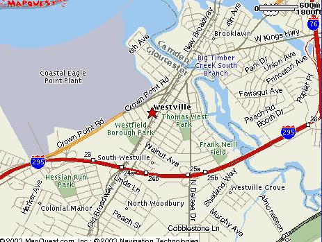
Mapquest map of
NJ - Westville/ Gloucester City area
[zoom in]
Coins,
Weights and Measures Mentioned in Dutch Records
Cor
Snabel's Old Dutch Measurement
[archived version]
NOTE: The information below is the OPINION of the webmaster. If you have data that would disprove any of this information, please contact me and I will post same.
Background: John Sheppard, originally of Woodbury now living in Ohio posed this question to me after reviewing this web site: "Do you have any knowledge of Fort Nassau? It was built in 1623 by Captain Mey and was considered the first Dutch settlement in the area, supposedly at the mouth of Timber River in Gloucester. It has been lost in time." To answer his question:
FORT'S HISTORY | LOCATION OF FORT NASSAU | ORIGIN OF THE NAME
HISTORY OF FORT NASSAU IN BRIEF:
"In 1621, the privileged West Indian Company was formed in Holland. In 1623 this company dispatched a ship loaded with settlers, subsistence and articles of trade, under the command of Cornelius Mey. He gave his own name to the cap at the northern part of the Delaware Bay which it still retains--Cape May. He built a fort by a stream called by the natives Sassackon. It is a tributary of the Delaware, a few miles below Camden. He named the fortification Fort Nassau. It is highly probably that this was the first attempt ever made to form a settlement on the eastern shore of the Delaware. David Pieterson DeVries, who arrived in the Delaware in the winter of 1630-31, found that Fort Nassau had fallen into the hands of the Indians. He built a fort, colonized his immigrants, and went back to Holland." †1
HISTORY - CONFLICTING STORIES:
Depending on which history you read [both in print and on the internet], each contains a slightly different version regarding the origin of Fort Nassau, its history, and its location.
According to the history of Westville, found on their web site [my personal comments are highlighted in red] " After Cornelius Mey established the first white settlement on Burlington Island, he established Fort Nassau in 1623. The site of Fort Nassau has been a subject of much controversy, the Hon. Frank H. Stewart, president of the Gloucester County Historical Society has set the site as back of what is now Brooklawn, at the mouth of Timber Creek, just west of where Big Timber Creek, Little Timber Creek and the Delaware join. Records show that the Dutch trading post was "about fifteen leagues up the river on the eastern shore. The Dutch had built two strongholds or forts, largest about 16 miles up the river on the eastern shore, called Nassau". [There are inconsistencies in the measurements indicated here--is it 15 leagues or 16 miles? Did they mean to say furlongs instead? 15 furlongs = approximately 2 current miles, i.e. 15 x 0.125. The original Dutch navigators would not have used the term league.] In 1651, Peter Loursenson, a Dutch sailor sent to the Delaware, commented that Fort Nassau consisted of a trading house with ten or 12 servants belonging to It. Records further show that Nassau was occupied by 20 men and was used by the Dutch until 1651. In 1651, Fort Nassau was abandoned. Its cannon and other weapons were installed at Fort Casimir (at New Castle). Its last trading commissioner Andries Hudde, served in the same capacity in the new fort. The abandoned fort remained a landmark for many years. In 1750, Acrelius, pastor of the Old Swede Church, Philadelphia, wrote in his diary, "Nassau is still standing two and a half miles north of Manias Hook (Hantaes hoeck)." [note the spelling here is incorrect, should be Manta's Hook [Mantaes Hoeck].
According to "Accessible Archives: "it appears that the sailors and soldiers were stationed at a little fort which was hurriedly built for their protection at a spot which the natives called "Tekaacho" near Gloucester Point, immediately opposite the lower part of the city of Philadelphia. This was Fort Nassau, the first building known to have been erected by civilized men on the shores of the Delaware. Its exact site cannot now be pointed out, but it was supposed to be upon the north branch of Timber Creek or as the Dutch called it "Timmer Kill," (21*) then called "Sapackon." It was built close to the point of rocks, its southern rampart being within a few feet of the creek.(22*) The year in which the fort was built is disputed, but it is probable that its construction was undertaken about 1623, which was doubtless also the time of the settlement near the site of Trenton. The men and women of the Walloons at this isolated station grew homesick, and within a year or so returned to Manhattan. The fort too was abandoned after one or two years of occupations though it was irregularly occupied by a few soldiers for short periods, down to 1642 when it was continuously garrisoned until 1650 or 1651 when the Dutch themselves destroyed it, because it was too high up the river and too far from the chief theatre of their activities to serve any valuable purpose. It appears to have been occasionally used as a lodging place by the Indians, probably at such times as they expected trading vessels to arrive which was at least once a year, and De Vries found it thus tenanted by the savages when he visited it in 1633."
[(21*) On the map in Campanius’ work it is designated as being between the two branches of Timber Creek.
(22*) Various discoveries and relics have been made at different times in digging at the site of the fort. In 1745 a Spanish privateer threatened to land on the Delaware, and fears being entertained that they would attack Wilmington, attempts were made to place the old fort in repair. In digging the ground for that purpose, they found several pieces of money, with Queen Christina’s stamp upon it. On the 31st of March, 1755, on taking up by chance some pieces of the walls, there were found many cannon balls, granadoes, and other similar things, which had been kept carefully concealed since the surrender of the fort by Rising. Five pieces of cannon (according to Acrelius) wore kept mounted there previously, as at the treaty of Aix la Chapelle, in 1646, an English salute was fired from them, in honor of the Governor, who was going to meet the Legislature at New Castle.]
According to PICTORIAL FIELD BOOK OF THE REVOLUTION by Benson J. Lossing: "Near where Gloucester, in New Jersey, now stands, he built Fort Nassau. This was the first white settlement on the shores of the Delaware, but it was not permanent. In 1631, Captain David Pieterson de Vries entered the Delaware River with two ships and about thirty colonists. He was associated with Godyn, Bloemart, and Van Rensselaer, wealthy Dutch patroons, 9 in establishing a permanent settlement on the Delaware for the purpose of cultivating tobacco and grain, and prosecuting the whale and seal fishing. He built Fort Oplandt, near Lewiston, Delaware. De Vries returned to Holland, and when he came back, in 1632, his colony was destroyed. The arms of Holland, emblazoned on a piece of tin, had been raised upon a pole. An Indian stole the metal to make a tobacco-box of it. Osset, the commander, quarreled with the Indians, and the latter fell upon the colonists, while at work in the fields, and butchered every one of them. De Vries made peace with the tribe, but, finding Fort Nassau deserted, and the whole settlement a desolation, he left the bay forever; for, before the Dutch could re-establish their power, the patent granted to Lord Baltimore, proprietor of Maryland." †3
According to Area History: Contents of Vol I, Advertisement, & General Introductory History - Watson's Annals of Philadelphia And Pennsylvania, 1857, front section:
"About that time, the States General appear to have enlarged their schemes
of profit from the country, by an attempt at colonization; for they grant,
in the year 1621, their patent "for the country of the Nieu Nederland, to
the privileged West India Company". From this time the Dutch began to
progress southwardly over the lands bordering on both sides of the Delaware,
which they then called the Zuydt or South river, in contradistinction to
their Noords or North river. To protect their settlers, they built in 1623,
their first fort on the Delaware, and probably made their first village, at
the place since known as Gloucester point, in New Jersey, at a little
distance below the present Philadelphia. This was of course the proper
"Ancient Dominion", to us ! The fortification was called "Nassau". The
place was known to the Indians by the name of Arwanus [also as Tekaacho] and
by the ancient Philadelphians by the less poetical name of Pine point."†5
According to: Local History: Chapters IV & V - Part I: Early Voyagers and Traders & The First Swedish Settlement: Bean's 1884 History of Montgomery Co, PA:" p 54
"Mey, appears either to have accompanied them here or visited them soon after their arrival. He selected a site for their settlement, planting the Walloons on Verhulsten Island, near the present city of Trenton, N.J., and hastened the construction of a log fort or stockade for his sailors and soldiers at the mouth of the Timmer Kill, on the New Jersey bank of the Delaware, not far from where Gloucester now stands. This fort was called "Nassau." Its exact site is not determined, nor can we decide the original Indian name of the spot, having such a variety to choose from. [See NOTE 4-6.]
[NOTE 4-6.] Hermaomessing, Tachaacho, Armewamix, Arwames, Tekoke, Armenvereus,
etc. The year in which the fort was built is also disputed, but the circumstances mentioned in the text make it probable that its construction was undertaken very shortly after Capt. Mey's arrival.
LOCATION OF FORT NASSAU
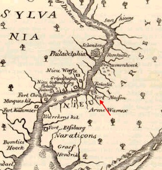
Much debate continues to this day on the exact location of Fort Nassau. In order to determine where it was, one has to go back in time to review maps and documents of the time, and compare them with current ones.
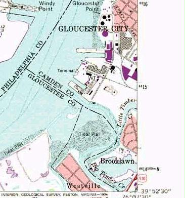
If you review the maps below, it becomes evident that Fort Nassau sat at the mouth of Big Timber Creek, on the south side. As was typical of the early Dutch forts, it probably was located right at the waterfront, with a bridge traditionally leading down to the water. [See pictures of Fort Christina (Wilmington DE) and Fort Casimir/Trinity Fort (built afterwards]. In the 1662 map (Map #1 below) it does not appear to sit exactly on the point of land that touched the Delaware River, but rather sat exactly at the mouth of the river on the site of current Westville, N.J. [Westville Borough was incorporated in 1914].
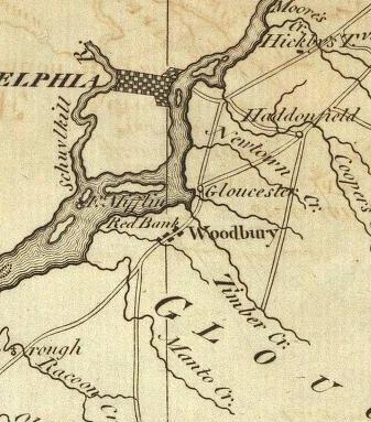
Map #2 - 1685? - A map of ye English Empire in ye continent of America : viz Virginia, Maryland, Carolina, New York, New Iarsey, New England, Pennsilvania / W. Binneman sculpsit. Creator: Daniel, R. (Richard), -- Cartographer [See entire map]
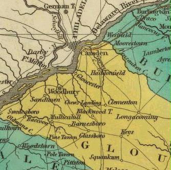
Map #3State of New Jersey
1795 National Atlas by Mathew Carey
[see full map]
Map #4
New Jersey.
1831 World Atlas, Mathew Finely
[see entire map]
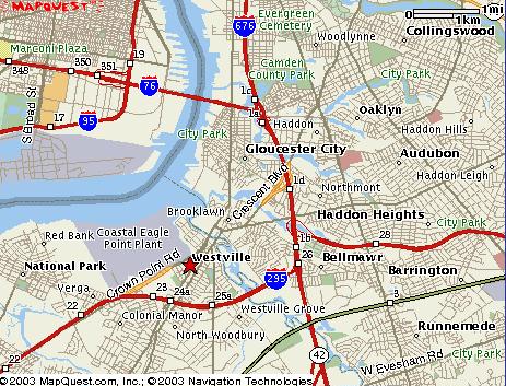
Map #5 - A current map of the entire area of Gloucester City, Westville and Deptford; notice how the two branches of Timber Creek contain Brooklawn between them, Westville is to the south of the lowest branch.
Map #6
Close up of Modern Day Camden/ Westville/ Deptford area.
Map #7
Section of Rutger's Geography Department, Topographical Map of 1950's; quadregion 11
The light red area [part of Westville] at the bottom of the picture is at the mouth of the Big Timber Creek.
ORIGIN OF THE FORT'S NAMES [NASSAU & CASIMIR]
[Regarding Fort Casimir]: July/Aug 1651: "As soon as the guns were mounted, some having been brought from Fort Nassau, that fort was taken down, and the soldiers and settlers there--a dozen or more families--were brought down the river to the new fort, which Stuyvesant called Fort Casimir...Why Casimir? They wrote: "We are at a loss to the conjecture for what reason it has received this name." The fort was named for none of them, but we may suppose for Count Ernest Casimir of Nassau, one of the heroes of [Peter] Stuyvesant's native Friesland, stadholder of that province from 1622 to 1631 during Stuyvesant's youth and early military career...In 1623 the first fort on the river under West Indian Company had been called Nassua, perhaps for this same Count Ernest, whose greatest victory was then recent... †2
Questions:
How far exactly is a league? According to a math book of the last 1700's and historical tradition [adopted by the Romans as the Leuga, it was supposed to represent the distance a person could walk in an hour, it became equal to 3 miles. This would place the fort 45 miles up [from the mouth of the river].
Sources:
†1) "History and directory of Warren County, New Jersey" by Frank Shampanore; Washington, N.J.; Shampanore & Sons, 1929, page 6a
†2) New Castle on the Delaware; New Castle, Del.: The Society, c1936, 173 pgs.
page 24
†3) PICTORIAL FIELD BOOK OF THE REVOLUTION by Benson J. Lossing, Vol **, 1850
†4) A COLLECTION OF MEMOIRS, ANECDOTES, AND INCIDENTS of the CITY AND ITS INHABITANTS and of the EARLIEST SETTLEMENTS OF THE INLAND PART OF PENNSYLVANIA from THE DAYS OF THE FOUNDERS, by John F. Watson, written c1830-1850; published 1857
†5) Area History: Contents of Vol I, Advertisement, & General Introductory History - Watson's Annals of Philadelphia And Pennsylvania, 1857

Reference | Photographs | Contact | Site Map
Copyright © 2003-2020 | Janice A. Brown | All rights reserved.