|
|
| |
 W
A T E R W A Y S of East Greenwich W
A T E R W A Y S of East Greenwich |
| |
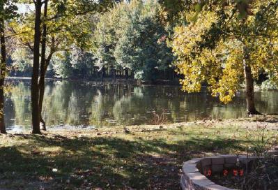
| Scene
in East Greenwich NJ, from the East Greenwich Master Plan 2004 |
East
Greenwich Township is drained by the Mantua Creek, which forms its northern boundary
line, the Repaupo, which forms a part of its southern boundary line, the Still
Run, Repaupo, Nehansey Branch, and Clonmill Creek, the three latter taking their
rise in or near the central part of the township, running in a southwesterly direction,
emptying into the Delaware River. [Cushing, 1883]
The
early white settlers built saw and grist mills on many creeks
and streams throughout the county.
These early mills encouraged development of flood plain land and
established a trend for development that continues today. Agriculture
was also an important industry for the early settlers and continues
to be one of our major industries.
In
addition, our waterways (creeks and rivers) were often used for
transportation. Several wharves could be found along the Mantua
Creek where boats and barges would carry vegetables and fruit
grown locally (along with other products) to Philadelphia and
other ports. They brought back goods from that city to our township.
[SEE
GLOUCESTER COUNTY WATERSHEDS]
CLONMELL
CREEK [Gibbstown]
Lat, Lon (wgs84) 39.83955, -75.28241
N 39°50'22"
W 75°16'57"
Part of the Repaupo
Creek Watershed.
Probably named after Clonmel
in Tipperary County, Ireland. Captain
Israel Helm, one of the early leaders of "New Sweden"
lived by this Creek.
MANTUA
CREEK
Mantua Creek (MAN-chuh), c.16 mi/26 km long, Gloucester co., SW
N.J.; rises N of Glassboro; flows generally NW, past Wenonah and
Paulsboro, to Delaware R. opposite S Philadelphia. Navigable for
c.9 mi/14.5 km above mouth. Part of the Mantua
Creek Watershed
TIDE
TABLE FOR MANTUA CREEK
Mantua
Creek and its two major tributaries, Edwards Run and Chestnut
Branch, drain over 50 square miles of Gloucester County.A
major tributary to Mantua Creek, Chestnut Branch flows just over
seven miles from Glassboro to Mantua. Over that stretch it drains
9.9 square miles of land. Edwards Run, the second major tributary,
flows north for 6.9 miles from its headwaters in Mantua Township,
through East Greenwich and empties into Mantua Creek at Mt. Royal.
Edwards Run drains an area of 10.6 square miles. Duffield Run
is also a tributary to Mantua Creek from the headwaters and drains
an area of 2.3 square miles.
LEARN
ABOUT WATERSHEDS. The
Mantua Creek Watershed is part of the Lower
Delaware River Tributaries Management Area.
History
of Settlement near Mantua Creek
The early settlement of the Mantua Creek area dates back to the
time of the Lenni-Lenape Indians. The Indians valued the area
for its abundance of fish and game and utilized the creeks extensively
for transportation. By 1643 there were Swedish settlements along
the banks of Mantua Creek, as well as all the other tidewater
creeks between
Fort Nassau and Fort
Elsinborg. The W.P.A. "History of the Swedes and Finns"
tells us that 'Tobacco once grew between Racoon and Mantua
Creeks, and along the banks of Mantua Creek were found great quantities
of walnut, peach, chestnut, cypress, mulberry and fish trees,
as well as many rare trees, unknown because they could not be
found anywhere other than in this area. The shores of the creek
were infested with a horrible serpent, called a rattlesnake.'
Some histories claim
that the word Mantua is derived from the Lenape word, "frog." According
to According to Jim Rementer, Language Director for the Delaware
Tribe of Indians (currently in Oklahoma), "Manta" or "Mantua"
is not a known Lenape word. Older European-based histories indicate that "Manta
is a Lenape word for frog." According to Mr. Rementer, the Lenape word for
frog is "chahkol." According again to Mr. Rementer, Mantua or Manta
may have been a Native American village name. The closest phonetically sounding
word to this might be "manëtu," which means "spirit"
in the Lenape language.
The name Mantua is probably had the same
origin as "Mantas Hook" ["Mantaes hoeck" meaning Manta's Point
in Dutch, the Mantaes being the Dutch term for the Native Americans who lived
in this area] in Billingsport. The Manta (Mantes) were a Unalactigo sub-tribe
or division of the Lenape people based on differences in dialect and location.
The Unalactigo, "people near the ocean," inhabited both sides of the
lower Delaware River below Philadelphia including Delaware Bay in what would currently
be northern Delaware, southeast Pennsylvania, and southern New Jersey. Case in
point--on John
Worlidge’s Map of East and West Jersey, c. London, 1706 Mantua Creek
is referred to as Mantaes Creek; on
a 1777 map it is called Manto Creek; on
an 1872 map it is called Mantau Creek. Other meanings of "mantua"
during this same time period was a woman's cloak or mantle; also, a loose woman's
gown of the 17th and 18th centuries--coming from the term which also means a rich
kind of silk [formerly exported from Mantua, Italy]. A maker of women's silk clothing
was known as a "mantua-maker."
According to "The Pennsylvania
Evening Post, (Philadelphia), February 3, 1778:"
Yesterday about twenty
West Jersey loyalists crossed the Delaware, from this city, in order to assist
some of their friends, who had expressed a desire of taking refuge here, to avoid
the horrid tyranny and implacable persecution of the rebels. At the mouth of Mantua
creek, they fell in with a party of the enemy in ambuscade, whom they soon repulsed,
advanced into the country, and took one Wilson prisoner, who was a committee man,
and, it is said, very active in distressing the friends of government. They returned
this day with the prisoner, and their friends. The loyalists had one man killed,
but what the rebels suffered is not known. Wilson is in confinement. There
was also a 2nd skirmish at Mantua Creek.
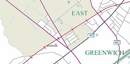
NEHONSEY [sic
"Nehansey"] BROOK/CREEK - Today, Mickleton is considered roughly
that section of East Greenwich Township south of the source of the Nehonsey Creek
[also referred to as a brook and a stream]. Where exactly is Nehonsey Creek? [see
map below]. "Peaslee Pond" is the visible location
of the dividing line between Mickleton and Clarksboro.
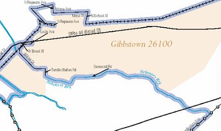
| |
| Nehonsey
Brook/Creek as shown in Gloucester County GIS map |
| |
 PEASLEE'S POND
- a small body of water on the Peaslee estate visible from King's Highway
in Clarksboro. Many older residents of the town remember ice skating on this pond
in the winter time.
PEASLEE'S POND
- a small body of water on the Peaslee estate visible from King's Highway
in Clarksboro. Many older residents of the town remember ice skating on this pond
in the winter time. |
Will-O-Dell
Lake, in actuality a small pond formed by Nehonsey Brook, is
located off Friendship Road near Harmony Road. This "lake"
may be remembered by township residents as a place where they took
Red Cross swimming lessons. According to Suzanne Grasso of the Gloucester
County Historical Society, "the Ahrens family bought the Eisler
Farm back in the 1930's. In 1952 they decided to dig a lake and
open it for recreation, build the consession stand, restrooms etc.
In 1955 the lake opened to its members. The family ran and maintained
the lake. The lake was closed in 1974 because it had become too
much work for the families. The lake was sold and was to open again,
and then sold again. Unfortunately it never reopened again as a
recreational lake. There were 3 willow trees that were left on a
little "island" in the middle of the lake, which would
most likely explain the name. They eventually died because it was
too wet. "
Cindy Pokrzywa remembers: "Probably the most fondest childhood
memories for myself and the rest of my siblings are those summers
we spent at Will-o-dell lake. Would love to somehow plan some sort
of gathering/reunion to celebrate what it meant to belong to such
a special place. It was not just a place to swim, It was a place
where I learned to dance, play VolleyBall, badminton, and so on!
I may even have some pictures..I live in Woodstown and to this day
I still drive by what's left of the lake and think back to those
summer days. Thanks for remembering Will-O-Dell."
(My thanks to Larry Chester for bringing this "lake" to
my attention. Anyone who remembers this lake, or has photographs,
please contact me.)
RATTLING RUN
Tomlin Road
Part
of Repaupo Creek
This stream rises a little west of what what was
the "Jefferson" section of Harrison Township, and flowing westwardly,
supplies Warrington Mills [the old mill pond of Judge Warrington] after which
it takes the name of Purgy Creek, thence emptying into the Repaupo.
STILL RUN
Quaker Road
Part
of Repaupo Creek
According to Elizabeth T. Scott in "East
Greenwich Township Centennial--1881 to 1981," tradition says that at the
entrance of Still Run with Homan's Creek was a point of land with a cluster of
Native American wigwams. The occupants resided there for a long time and were
peaceable.
Both Rattling Run and Still Run are part of the Lower
Delaware River Tributaries Management Area
EDWARD'S RUN /
EDWARD'S CREEK
Part
of Mantua Creek Watershed [Lower Delaware Watershed]
Edwards Run, the
second major tributary of Mantua Creek, flows north for 6.9 miles from its headwaters
in Mantua Township, through East Greenwich and empties into Mantua Creek at Mt.
Royal. Edwards Run drains an area of 10.6 square miles.
This waterway
originally emptied into Mantua Creek near the railroad tracks but the course of
the stream was diverted by Restore Lippincott. This creek was named in honor of
Edward Byllings, an early owner of the land in our township.
Edward's Creek at Gerrard's Dam, was the line between Mantua and
Greenwich before the creation of East Greenwich Township.
HOMAN'S
CREEK aka Trumpeter's Creek
is the old name for Repaupo
Creek. Repaupo
Creek rises on the line separating Greenwich from Woolwich township,
and flows northwest 7 or 8 miles to the Delaware River, opposite
Chester Island.
It was
named after
Anders Andersson Homman (1626-1700) the former trumpeter for New
Sweden from Sollentuna
parish in Stockholm Sweden, who had arrived in America with Governor
Printz in 1643 and later became one of the first settlers on Repaupo
Creek (also known as Trumpeter's or Homan's Creek) in Gloucester
County, New Jersey. Peter Homman his son (c1675-1729) lived in
Passyunk as a hired hand, and he himself returned to Gloucester
County in 1706 when he was named constable of that county. There
is no evidence that Peter ever married. (Pennsylvania Genealogical
Magazine vol. 36, no. 3).
Before 1684 Woola Erickson, Hans Petters, Andreas Homan and Israel
Helm purchased tracts close to Repaupo Creek from the Swedish
owners.
In 1702 a land transaction was recorded as follows: "Do.
to Peter Long of 1,000 acres, surveyed in 1685 to Andrew Robeson,
on Maple Run and another branch adjoining the Parkers and including
20 acres of Homan's Creek.
More
information on other Watersheds in Gloucester Co. NJ |
|